Return — hut on a point
IT’S BEEN DECADES, I thought as the driver throttled back the engines to approach the jetty. Decades… and there was no jetty, no fast catamaran then… just an old wooden launch captained by a man in late middle age. Not the roar of powerful outboards then, just the putt-putt-putt of an old diesel.
Today’s catamaran journey is faster and in the days of the putt-putt there was no safety talk before setting out, no instructions on how to put on a floatation vest (even if they were provided on that old vessel), on how to climb onto the hull to await rescue if the vessel flips over, of survival changes floating in this cold lake.

It’s not that we usually took the putt-putt to reach this minor promontory on the lake. And the lake… Lake St Clair is a long curving finger of water carved by a Pleistocene glacier gone over 12,000 years ago. At around 200 metres it’s Australia’s deepest lake and probably its coldest.
Usually, we would walk the lakeside track en route to the mountains to the north or in return from them. Heading south we would leave the button grass plains of Narcissus and enter the lakeside rainforest. Come through in the cold season when snow rested on the Antarctic beech (Nothofagus cunninghamii) and you were likely to have it dumped on you and feel its coldness slip down under your shirt, a chilling experience, and moist. The track would be more a running stream then and it would flow over the top of your boots — cold, wet feet was something you lived with in the mountains. A muddy track was your experience no matter what the season. And then there were the leaches.
Echo Point, then, was a waypoint on the journey through the dark interior of a mossy and moist, cool temperate rainforest. It was a day’s walk from Narcissus at the northern end of the lake to the end of the track at Cynthia Bay, or vice versa.
Once, we overnighted here at Echo Point in the small wooden hut whose old grey timbers have withstood the icy winds and the humidity where forest meets shoreline. There were five of us on that trip, I recall, David Cameron — a young man with an interest in Buddhism who later became a national park ranger, the Elwells from Hobart, Charmaine Gibson, who later took up criminal law, and myself, then working in the adventure equipment industry. Then, the shores of the lake were less frequently visited, the track rougher and a little more difficult — there was no duckboarding then and there was a wealth of mud.

RETURN
This is a story about return. Return is something that many of us do at some time in life, whether it’s return to a city we once lived in, a house we once inhabited, a place we once visited that holds memories. We return out of curiosity and sometimes a little fearful that time will have dealt badly with the places our memories are embedded in, yet we must make that return even if those places now exist only in memory.
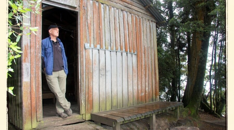
It was when we were thinking about where to go in Tasmania that the notion of return occurred to me — return to that tiny hut in the rainforest on the rocky shore of that finger lake. It’s not that the hut holds any significant memories for me — I’ve stayed in a good many huts in the mountains — it’s just something about its setting there by the lake, on the edge of the dark forest where the grey waters of Lake St Clair lap gently and across whose body of water the spire of Mt Ida reaches skywards from the Traveller Range. In the Pleistocene ice age, Mt Ida was a nunatak, a peak encircled by a glacier and protruding from it. The hut.. it was a place where we would take a break on the hike back to the trail head, a place where we would sometimes have lunch.

Return often brings disappointment at the changes that have occurred… places modified or gone, paddocks urbanised, places once sparsely visited now inundated by tourists, people once known now gone.
This I had anticipated of Echo Point and its hut. I was wrong. Apart from the jetty, the hut and its surroundings were much as they had been when I had last walked southwards away from it all those decades ago on the final hours of a solo, five day walk from Cradle Mountain. Sure, a little maintenance had been done to the hut… the small fireplace had been replaced by a coal stove and a toilet had been built nearby in the forest… yet it remains essentially unchanged. Inside, there’s still the double rack of bunks and a small table on which to prepare food or, if you’re overnighting here, on which to pour that mug of warming port on cool Tasmanian nights.
The catamaran left to deliver passengers to Narcissus at the northern end of the lake and on its departure the silence returned, the silence of the lake, of these mountains, the forest, of this wilderness. We spent some time at Echo Point that day, pottering on the lake shore and on the edge of the forest, checking out the shack, sitting quietly watching the mist hide then reveal the summit of Mt Ida on the far shore. This, I recalled, is as it has always been and it is as this place exists in my memory retained from those days decades ago when, much younger, we would come by here, take a break and bite to eat and to shelter when the weather wasn’t so good, there in the haven that is Echo Point hut.
Narcissus is around three hours walk north of Echo Point. There is a larger hut there on the banks of the river of the same name, and it is populated by walkers on their journey along the Overland Track. Reaching Narcissus Hut, they have only a day to go to the trailhead unless they have arranged to catch the catamaran back. There at Narcissus a few might extend their journey by following a trail into the forest and, a couple hours later, coming to Pine Valley hut. From here they might make the ascent to the Du Cane Range, to the elevated plateau known as The Labyrinth.

We walked back along the track that follows the lake shore through that dank, dank, green forest, stopping at some of the little sandy beachlets along the way. From Echo Point it’s only a four, at most five hour walk to Cynthia Bay depending on how fast you walk, what the weather is doing and whether you stop to photograph the forest with its moss-covered logs and tree trunks, its tree ferns (Dicksonia antarctica) and shrubs and scramble down to the little beachlets along the way.
Until we approached Watersmeet, close to the end of the trail, we encountered only a man and his daughter and a solo walker. The man and daughter were making for Echo Point and asked how far it was as they were concerned about running out of daylight. They would make it and be back before last light, I suggested, it they kept a good pace. The solo walker, an American, perhaps a Canadian, was headed north, the large pack on his back keeping him to a moderate pace.
On we walked through this quiet, cool temperate rainforest. Behind us, Echo Point grew ever more distant and soon all but the top of Mt Ida disappeared from view. Then the mist enveloped it and the peak and Echo Point again entered the realm of memory, memory old but memory renewed.
Photo…
Travel on Lake St Clair in the 1070s… the putt-putt.
